You knew this – but did you know
Louisiana Purchase was in 1803, this you already knew.
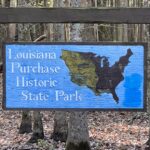
Friday, November 11, 2022, you knew this about the Louisiana Purchase – but did you know about the initial point from which ALL surveys of property acquired through the Louisiana Purchase originated.
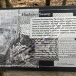
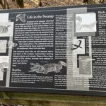
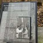
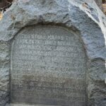
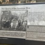
This is where it all started the Louisiana Purchase, where for $15 million dollars or less than 3 cents an acre, in 1803, roughly doubled the size of the United States, but the purchase needed to be surveyed before the land could be sold. It wasn’t until 1815 when President James Madison needed the survey, so he could award the veterans of the war of 1812 the land they had been promised.
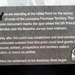
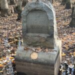
I’m not sure I understand this, but this is where that survey began where a north south line at the Fifth Principle Meridian & Baseline intersected. Not exactly sure where baseline came from. All surveys west of this point started here.
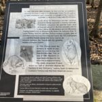
Here is a copy and paste from here – https://encyclopediaofarkansas.net/entries/louisiana-purchase-survey-2204/
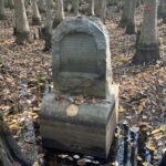
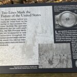
“The official land survey of the Louisiana Purchase began in October 1815, when two land surveyors, Prospect Robbins and Joseph Brown, set out on their journey from the Mississippi River. (Brown later became Surveyor General of Missouri for a brief period and surveyed the boundary between Arkansas and Missouri. Little is known about the surveyors except that they lived near Clayton, Missouri, outside present-day St. Louis.) Robbins began at the mouth of the Arkansas River and surveyed due north. Brown began several miles upstream at the mouth of the St. Francis River and proceeded due west. Brown’s survey line is called the baseline, and Robbins’s line is called the Fifth Principal Meridian because it was the fifth north-south line surveyed in the U.S.
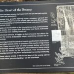
During this time period, surveying land was exceptionally difficult work. Using only a compass and a chain, surveyors made their way through the wilderness, stopping every half mile to mark or “blaze” a tree. They carried all of their provisions with them for a task that lasted several months. In the vast wilderness of the Arkansas Delta where Robbins and Brown worked, the only signs of life were scattered Indian and animal trails.”
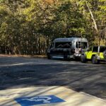
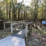
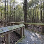
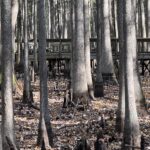
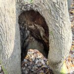
The park is about 38 acres total at the end of a dead end road and the parking lot is kinda small. We were prepared to unhook the jeep to get turned around but it was JUST big enough, since there were no one else there.
Because we had fair cell service and a short distance to go we sat there a couple of hours after walking the boardwalk to the marker site.
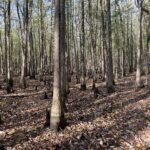
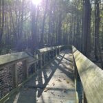
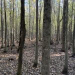
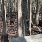
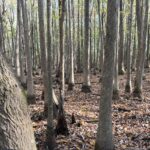
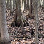
Can you see the straight line in the trees, that’s due west by the way.
The End

Please enter your name and email address to subscribe
**Click on photos to enlarge**
See all the pictures at RMTravels.smugmug.com
Hello
Welcome to my spot on the web. My wife and I are retired and live and travel full-time in our motorhome.
You can also find us on Facebook – RMTravels
Categories
Past Ramblings
Recent Posts
Recent Comments
- Rex on 2 nights in a pumpkin patch
- Rex on Please Read
- Gayle Van Sessen on Please Read
- Jim on 2 nights in a pumpkin patch
- Rex on This is a test
Archives
- October 2023
- June 2023
- April 2023
- March 2023
- February 2023
- January 2023
- December 2022
- November 2022
- October 2022
- September 2022
- July 2022
- June 2022
- May 2022
- April 2022
- March 2022
- February 2022
- January 2022
- November 2021
- October 2021
- September 2021
- August 2021
- July 2021
- June 2021
- May 2021
- April 2021
- March 2021
- February 2021
- January 2021
- December 2020
- November 2020
- September 2020
- August 2020
- July 2020
- June 2020
- May 2020
- March 2020
- February 2020
- November 2019
- October 2019
- September 2019
- August 2019
- July 2019
- June 2019
- May 2019
- March 2019
- February 2019
- January 2019
- December 2018
- November 2018
- October 2018
- August 2018
- July 2018
- June 2018
- May 2018
- March 2018
- February 2018